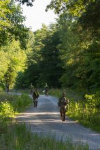
Cadets from 4th Regiment Advanced Camp, move on in search of points during the Day Land Navigation exercise, Fort Knox, Ky., Jun. 14, 2019. | Photo by Kyle Crawford, CST Public Affairs Office
FORT KNOX, Ky. — Fort Knox’s training ground for Land Navigation is wet, heavily forested and teeming with wildlife, but it’s also where the Cadets of 4th Regiment prove they have what it takes to find points in the wild without the help of technology.
Sgt. Jonathan Shyrock, of the 3-61 Cav 4th ID, is the non-commissioned officer (NCO) officer in charge (OIC) at the communications station for the area, and has been enlisted in the Army for eight years. So he has seen his fair share of courses.
He noted that the course may not be hard for someone that has been doing Army Land Navigation, but for the Cadets who may not be familiar it can be tricky. Obstacles like water submerging points, thick vegetation that can cover the point you may be looking for and just the different critters that live in the woods all come together to make the course a challenge for Cadets new to Land Navigation.
“It’s like a moderate course,” Shyrock said. “If you had to rate this course one out of ten. This would be like a five or six. The biggest challenge for them is making sure they plot their points before they go out.”
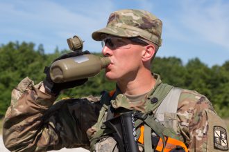
Cadet John Aljets, Iowa State University, 4th Regiment Advanced Camp, enjoys water from his canteen after completing the Day Land Navigation exercise, Fort Knox, Ky., Jun. 14, 2019. | Photo by Kyle Crawford, CST Public Affairs Office
Albert Cain, a Cadet from the University of Memphis, said that he had experience with Land Navigation before back at his university and that the practice really helped prepare him for the terrain here at Fort Knox. But even with experience he pointed out that the swampy nature of this course is a big problem the Cadets have to overcome.
“The most challenging thing would’ve been the weather we’ve had recently,” Cain said. “The terrain itself isn’t too bad, but what you have to take into account is once it starts raining, that low terrain becomes a swamp. And that’s really hard to avoid, when sometimes all of our points are in the middle of that, but you just have to go in and deal with it.”
Sarah Didonna of Bismarck, North Dakota, has experience as well in Land Navigation from her time back home. She said that she had underestimated the sheer size of the almost 1,800 sq. km. course her first time through and made sure that she kept it in mind for today’s test.
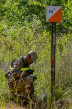
A Cadet from 4th Regiment Advanced Camp records the discovery of one of his assigned points during the Day Land Navigation exercise, Fort Knox, Ky., Jun. 14, 2019. | Photo by Kyle Crawford, CST Public Affairs Office
“When we first went out, what challenged me the most was not knowing the scale of the course,” the North Dakota State University Cadet said. “I underestimated the length of each trail. I walked it and ended up running out of time. So I wasn’t able to collect my points yesterday, but today I was able to understand the length of the trail and so I was able to get to my points on time.”
And for Cadet David Acampora, the vegetation and terrain can lead to times where you may question yourself and cut into the four hours each Cadet has allotted to find their points.
“The most challenging part of Land Nav is the disagreement with your instinct and your self-doubt,” the Ramsey, New Jersey native said. “You follow the map, but there is always that self-doubt that you’re doing something wrong or you don’t trust your skills or the practice you have may not be valid or this doesn’t look exactly like it does on the map. So just trusting yourself a little bit and learning when it’s ok to doubt yourself is the most challenging part.”
Acampora has experience with Land Nav and offered some advice to the future Cadets coming through the Fort Knox training ground.
“The best advice I could give is pay attention when you’re walking around the course before the test,” the Bucknell University Cadet said. “And start to understand where things are beforehand because the less you need the map for, the better.”
Losing that time and being nervous about plotted points was something echoed by Cadet Chance Cumpton from the University of Central Missouri and Jefferson City, Missouri, native.
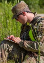
A Cadet from 4th Regiment Advanced Camp, studies his score card during the Day Land Navigation exercise, Fort Knox, Ky., Jun. 14, 2019. | Photo by Kyle Crawford, CST Public Affairs Office
“I guess the only super challenging part was being confident before you stepped off,” Cumpton said. Making sure you have all of your points plotted correctly. Other than that, it was a pretty good course.”
He added that he had done Land Nav before but the course was nothing like this.
“I have done it [Daytime Land Nav] before, but nothing quite to the extent of Fort Knox,” Cumpton said. “The courses back home were always still wooded but nothing amped up to quite this extreme. There’s more dense forestry here.”
He also had some advice for the future Cadets who will be trekking through the mud and woods here at Fort Knox.
“Yeah, trust yourself,” Cumpton said. “Don’t always trust the Cadet trails. They take a lot more bobbing and weaving then if you just know where you are going. Trust your compass and trust your pace count.”