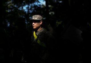
FORT KNOX, Ky. — Cadets from 1st Regiment, Basic Camp continued land navigation training today as they learn to plot points and identify terrain marks during terrain association map reading, July 3.
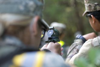
Cadets practice using the compass at Fort Knox, Ky. July 3, 2019. This training teaches Cadets how to properly use equipment to locate positions on a map. | Photo by Dustin Massengill, CST Public Affairs Office
Cadets of all skill levels become equals during the training. Cadets with no experience can expect to leave the training with a valuable skill set for any Solider.
“I think we are all confident now,” said Cadet Kristen Maxwel, University of Delaware. “We have all been doing this for a few days, but some of us do have more experience than others and we try to help.”
Maxwel and Cadet Padraig Feain, University of Washington, are both experienced with land navigation and try to help out their battle buddies and teammates whenever they can.
“I’m fairly confident in [land navigation],” Feain said, “I’m here to be here, be the best battle buddy I can be, keep the practice up and find all my points.”
Cadets from 1st Regiment, Basic Camp learn about different terrain features during the map reading training at Fort Knox, Ky. July 3, 2019. This helps prepare to navigate different obsticles as well as look for natural land marks when searching for points. | Photo by Dustin Massengill, CST Public Affairs Office
The terrain association training teaches Cadets to use their compass, identify terrain features, which can act as landmarks, and keep pace for counting distance.
Even Cadets with some training found issues to work out at the training. Cadet Keyshonda Ison, Alcorn State University, was excited to take on Land Navigation after being retrained on how to use the compass.
“I’ve been in ROTC for a year, and I’ve done land navigation before, but I’ve never found a point,” she said. “I realized I might not have been using the compass correctly. I never used the compass-to-cheek method, I always used the center hold method, but I didn’t use the bevel [when using the center hold method.]”
“Now that I have been trained on how to use it, I think I’ll find a point,” she added.
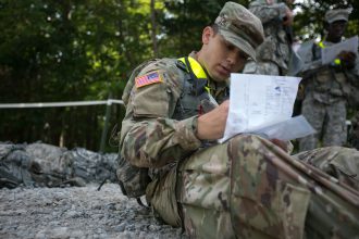
Cadet Chadwick Allison, Widener University, from 1st Regiment, Basic Camp plots two basins during the map reading training at Fort Knox, Ky. July 3, 2019. This training teaches Cadets how to properly use equipment to locate positions on a map. | Photo by Dustin Massengill, CST Public Affairs Office
The center hold method is where the compass is held out from the center of the stomach and lays between two L-shaped fingers, using the pointer and thumb fingers. This method is less accurate but is preferable in low lighting situations according to the army study guide.
The compass-to-cheek method is where the compass is pressed against the cheek under the nasal cavity and is held with a grip similar to the way a user would hold a pistol. This method is more accurate, but is only effective in good light and when a precise direction is not required according to the army study guide.
Cadets with no experience had the most to learn during the training, but were made comfortable by relying on their battle buddies.
“I haven’t done anything related to Army ROTC,” said Mario Reynaldo Bajenting, California State University, Long Beach. “ I rely on my battle buddy, I trust him to be there for me when I need him.”
“I was doing map reading earlier and was kinda off the mark,” Bajenting said, “But [my battle buddy] helped me zero in and figure it out.”
The Cadets were able to complete the training and grow as a group. They learned practical Soldier skills and how to lead as an equal by being good battle buddies.