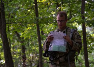
Traversing unfamiliar terrain is one of the biggest hurdles for Cadets to overcome at the Land Navigation tests, but with some careful planning anyone can succeed.

Cadets from 3rd Regiment, Advanced Camp trekked across varying terrain features of the Fort Knox, Kentucky, wilderness to find three of four points in under four hours as part of the Land Navigation (Land Nav) Test.
For those unfamiliar to the area, the high brush, dense woods, and critters can sabotage and cause them to fail, especially when all you have is a compass and a map to aid you.
Cadet Gabrielle Meyo, from Creighton University, mentioned that she felt very nervous when she arrived at the course, but not unequipped to face and pass the test with a little forethought.
“I went through a lot of rehearsals with my Cadre and I’ve been out here a couple of times,” Meyo said. “So, knowing the roads and everything helped me feel more ready.”
The Land Nav refresher that Cadets complete the day before, proved to be quite effective for Meyo, but also for Cadet Colton Scoggins, from Auburn University.
“My course back home is pretty tough and so I was pretty confident coming in.” Scoggins explained. “We did the refresher and I got both my points fairly easily, so I just walked around and explored the course.”

The refresher gives Cadets many opportunities to figure out how they can improve their navigation skills.
When it came to test day, Scoggins emphasized planning as a key to his success.
“I just follow what I wrote down when I was planning,” Scoggins continued. “I probably spent like a good 25 minutes plotting my points and really making sure my distances are accurate because I know my pace counts are always dead on.”
Twenty-five minutes can seem like a lot of time, especially when it is dedicated to sitting and planning rather than actually walking the course and finding your points. However, completing the course in under two hours speaks to how much that planning can help a Cadet.
“I think it’s important you just stay calm and write down your plan that you’re going to use instead of just jumping right into the course,” Cadet D.J. Pollino, of Wheaton College, said. “Cause that’s how you’ll easily get lost out here.”
While Polino found all four of his points with plenty of time to spare, one problem still troubled him.
“There’s gonna be that one point that’s really hard to find. It’s important to not get frustrated.”
Polino, rather than getting frustrated, fell back on his planning to succeed.
“It was the last point actually,” Pollino finished. “It was just a bit farther off a trail than I thought it was, but it ended up not being too bad. I just had to come back and take a different trail to find it.”